A week after the Noto Peninsula earthquake struck Japan on January 1, 2024, an unmanned aerial vehicle (UAV), or drone, delivered a supply of medicine to three people taking shelter at Konosu Elementary School. The roads connecting the Noto Peninsula with the capital city of Kanazawa in the south had left the school isolated for days, cut off from humanitarian aid. In addition to transporting supplies, drones helped to locate suitable places for temporary housing and examining the extent of the damage on the Peninsula.
The 2024 Noto Peninsula earthquake demonstrates the expanding role of drones in disaster relief and humanitarian efforts. By increasing situational awareness, reducing response times, and preserving resources, UAV technology offers greater efficiency and effectiveness. Despite the challenges of integrating drones into disaster management, real-time data can be gathered for accurate damage assessments, emergency supplies can be transported through impassable and dangerous areas, and communications can be restored.
While drones are unlikely to replace humanitarian vehicles and traditional disaster management tools altogether, they play – and will continue to play – an essential role in improving disaster responses and mitigating the impact of emergencies. By multiplying the effectiveness of traditional humanitarian operations, drones offer benefits that far outweigh their size and investment.
Drones For Disaster Relief
Drones in disaster relief are used primarily for (1) mapping and monitoring affected areas, (2) transporting and delivering essential supplies to victims, and (3) restoring communications.
Monitoring & Mapping
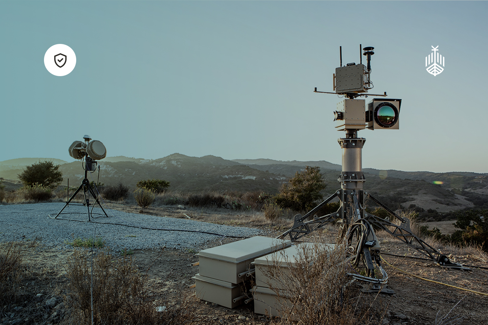
One of the most impactful uses of UAV technology in disaster relief is in mapping and monitoring emergency situations. In the aftermath of natural disasters, drones can quickly survey the landscape and create 2D or 3D models of the disaster site to provide crucial data on damage to infrastructure and the environment. Remote sensing capabilities and rapid spatial information collection provides quick and accurate damage assessment for rescue teams. During the Noto Peninsula Earthquake, the Ministry of Land, Infrastructure, Transport and Tourism relayed 3D-generated data from photos captured by drones to rescue teams. The images could be viewed from any angle and the distance and area between any points could be determined.
In the aftermath of Hurricane Harvey in August 2017, drones from Fort Bend County were used to assess damage to roads, bridges, and irrigation systems. Local and federal agencies like police departments, firefighters and environmental compliance inspectors collaborated with drone operators to identify and understand flooding and drainage problems. Later, insurance companies deployed their own drones to assess and confirm claims. According to spokesperson Justin Herndon for Allstate – an American insurance company – drones are especially useful for validating insurance claims because “you can zoom in at your desk to a single shingle and see the characteristics of that particular piece.”
Due to their relatively small size, drones can reach inaccessible areas such as flooded houses, impenetrable thickets, and debris-covered streets. By flying over areas that are otherwise inaccessible due to debris, flooding, or other hazards, drones can provide data in a fraction of the time it would take for ground teams to assess the damage. Also, response teams may be more accepting of a greater risk of losing them in zones which might be considered dangerous because drones are not as costly as manned aircraft. Similarly, since the remote pilot is situated in a safe location, away from any dangerous environments, unmanned aircraft can operate in situations where human safety would be a concern.
Equipped with noise, binary and heat sensing technology, drones are especially useful in search and rescue missions, where victims may be buried beneath rubble and debris and are not visible by the naked eye. Drones can therefore reduce the time spent searching for victims and locating routes that can be taken by responders on the ground. According to Reuters, during the April 2015 Nepal earthquake, drones were used for search and rescue missions. With the help of NASA’s FINDER device, “which uses microwave radar to detect miniscule motions of the body caused by processes innate to living things, such as heartbeats or respiration,” four people buried under rubble were found and rescued. While the device is not a drone itself, R4 Inc. is developing a model which can be attached to an octocopter drone.
For more information on the use of drones during and after the April 2015 Nepal earthquake see, for example: https://www.washingtonpost.com/news/innovations/wp/2015/10/07/in-nepal-a-model-for-using-drones-for-humanitarianism-emerges/
For more information on using 3D reconstruction software see, for example the Unity Engine Software
Transportation & Delivery
Drones are increasingly being used as cargo carriers in humanitarian efforts and disaster situations to deliver critical supplies such as water, food, lights, and medicines to victims and vulnerable populations. Damaged infrastructure or ongoing hazards post-disaster may prevent ground-based deliveries, making drones useful as they may be able to transport supplies to victims in dangerous, remote or isolated locations from the air. Due to their relatively small size, however, drones are limited by their payload capacity, and can typically only carry light cargo, therefore they may not yet be practical for larger aid operations which involve transporting heavier loads.
In more general humanitarian efforts, medicine and healthcare supplies can be transported to populations without immediate access to healthcare. In 2017, UNICEF collaborated with the Government of Malawi to determine the ability of drones to transport dried blood spots (DBS) to test for HIV and hepatitis C in young children. Since 2019, health facilities across Malawi – in, for example, Nkhata Bay, Likoma, and Mangochi – have received essential supplies and equipment including specimens for tuberculosis and HIV testing, blood pints for women giving birth, and COVID-19 vaccines. Other similar programs and experimental testing corridors for drone transportation have been set up over the last few years, such as in Vanuatu and Kazakhstan.
Communications
Another critical function of UAV technology in disaster relief is to restore communication networks. During natural disasters like hurricanes, earthquakes, and wildfires it is not uncommon for communication towers to be destroyed and power systems to be compromised. During disasters, however, telephone networks allow for communication, and ultimately the integration of relief efforts between first responders, relief teams and affected populations. Using ground-based power or other energy-efficient technologies, drones can hover in the sky for extended periods to provide emergency connectivity. Consequently, temporary communication infrastructure does not have to be set up, reducing the strain on resources. Drones can also act as Wi-Fi hotspots or transmit emergency radio frequencies so that victims can communicate locations and needs to rescue teams.
During the 2024 Noto Peninsula earthquake power outages and earthquake damage disrupted communications and cellular networks. According to the Ministry of Internal Affairs and Communications, “drones restored communications by relaying cell phone signals from users to cell phone base stations.” Two drones with radio relay systems hovered 100 meters above the ground. Powered by a ground-based wire, the drones were able to maintain a communication range of several kilometers for four days.
Drones in the Disaster Management Cycle
Mapping drones onto the disaster management cycle is a logical progression for integrating drones into disaster relief. They can contribute to every phase of disaster management, from anticipation and preparedness to response and recovery.
For more details on the disaster management cycle see: the UK Emergency Response and Recovery Guide
Phase 1: Anticipation and Preparedness
- Mapping to determine locations to set up temporary facilities and clinics for logistical planning, and inventory and aid kit preparation before disaster strikes
- Mapping and monitoring to determine potential ‘hot spots’ for disasters to evacuate populations as required
Phase 2: Response
- 3D mapping and monitoring to collect data about damaged areas and potential locations of victims for rescue
- Sensing technologies for search and rescue missions
- Restoration of disrupted communication networks
Phase 3: Recovery
- Mapping and monitoring damage to infrastructure for restoration and repair and insurance claims
- Delivery of aid to victims, including medicine, water, food etc.
Challenges: The Role of Government
Beyond technological limitations such as operational range and payload capacity or functional issues like weather conditions, there are three principal challenges associated with integrating drones into disaster relief.
Challenge 1: Public-Private Partnerships (PPPs)
Developing systems for collaboration and coordination between the public and private sectors ensures that drones are deployed safely and efficiently in disasters. Disaster relief efforts typically involve multiple stakeholders, such as government agencies, NGOs, private enterprises, and international organisations. Aligning expectations about roles and responsibilities between these stakeholders guarantees a more effective, efficient and coordinated response to disaster. Sharing aerial imagery and other data in user-friendly formats, for example, will help prevent redundant flights and streamline responses. Data sharing between public and private sectors is also essential for improving disaster response, and real-time mapping and damage assessment by privately-owned drones can inform rescue operations. The ability of private companies to provide advanced data analytics ensures that decision-makers in the public sector can respond more quickly and accurately, improving the overall efficiency of relief efforts.
The Ministry of Land, Infrastructure, Transport and Tourism (MLIT), Japan UAS Industry Development Association and KDDI SmartDrone were among those stakeholders involved in the response to the 2024 Noto Peninsula earthquake. The role of various government agencies, industry associations and private sector stakeholders, and the way in which they were able to collaborate during and after the earthquake demonstrates the importance in working together, pooling resources and expertise, and coordinating efforts in disaster management.
Challenge 2: Legislation and Regulations
While supporters of UAV technology champion its potential to transform disaster management and humanitarian work, industry experts caution the legal concerns it raises for governments and public agencies. Drones operate in environments where traditional aircraft and emergency personnel are also active, and unregulated drone flights can interfere with manned aircraft, which is especially dangerous in rescue missions. Clear and appropriate regulations therefore reduce the risk of collisions, interference with manned aircraft or accidents.
During the Noto Peninsula earthquake, drones were authorised to fly without permission or approval. This kind of legislation clarifies standards for operational safety, which can also include altitude and flight path restrictions. Moreover, legislation is necessary to integrate drones into the existing air traffic control systems, and therefore ensure safe operations. Additionally, legislation and regulation is necessary for accountability in order to determine who is responsible should something go wrong during a drone operation, whether a collision, property damage, or privacy violation.
Privacy and data protection concerns have also been raised as drones used for mapping and monitoring areas are equipped with high-resolution cameras and sensors to collect large amounts of visual and location data. In disaster zones, sensitive information about individuals’ identities, locations and private property might inadvertently be captured so this raises concerns about how the data is used, stored and shared: collected data, if not properly managed, could be vulnerable to internal misuse or external threats, and data about victims and displaced people could be exploited. In Nepal, citizens complained about the use of drones over the damage caused by the earthquake. According to a report by The Guardian, the Nepalese government established new regulations about the use of drones in disaster after concerns that drone footage had captured “images of historic artefacts ‘which could be misused later.’”
Conclusion
In conclusion, the application of UAV technology in support of civilian operations like disaster relief and humanitarian aid is vast and rapidly expanding. The diverse applications of drones in humanitarian and disaster relief indicates their versatility and effectiveness: they can map and monitor disaster-affected areas, transport essential supplies to vulnerable people and populations, and reestablish communication networks. Each of these benefits can be mapped onto the disaster management cycle to effectively integrate them into traditional management methods.
There are two principal challenges associated with integrating drones into disaster management and humanitarian efforts: first, public-private partnerships or other mechanisms for collaboration between government agencies and private sector stakeholders will be required to ensure that drones are used safely and efficiently. Second, legal issues related to operational safety, accountability and privacy will need to be addressed. Despite these challenges – which can certainly be overcome – the utility of drones extends to humanitarian and disaster situations. UAV technology is not limited to military applications, and has an important role to play beyond warfare.

.jpg)

.png)